


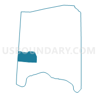
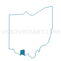
LIBERTY SOUTH Voting District, Adams County, Ohio
About
Outline

Summary
| Unique Area Identifier | 642444 |
| Name | LIBERTY SOUTH Voting District |
| County | Adams County |
| State | Ohio |
| Area (square miles) | 23.84 |
| Land Area (square miles) | 23.84 |
| Water Area (square miles) | 0.00 |
| % of Land Area | 100.00 |
| % of Water Area | 0.00 |
| Latitude of the Internal Point | 38.78300580 |
| Longtitude of the Internal Point | -83.63145980 |
Maps

Graphs
Select a template below for downloading or customizing gragh for LIBERTY SOUTH Voting District, Adams County, Ohio


Neighbors
Neighoring Voting District (by Name) Neighboring Voting District on the Map
- BENTONVILLE Voting District, Adams County, OH
- BYRD TWP Voting District, Brown County, OH
- HUNTINGTON TWP Voting District, Brown County, OH
- LIBERTY NORTH Voting District, Adams County, OH
- MONROE TOWNSHIP Voting District, Adams County, OH
- TIFFIN WEST Voting District, Adams County, OH
- WEST UNION WEST Voting District, Adams County, OH
Top 10 Neighboring County Subdivision (by Population) Neighboring County Subdivision on the Map
- Tiffin township, Adams County, OH (5,560)
- Huntington township, Brown County, OH (2,763)
- Liberty township, Adams County, OH (1,965)
- Sprigg township, Adams County, OH (1,867)
- Byrd township, Brown County, OH (739)
- Monroe township, Adams County, OH (686)
Top 10 Neighboring Place (by Population) Neighboring Place on the Map
Top 10 Neighboring Unified School District (by Population) Neighboring Unified School District on the Map
- Adams County/Ohio Valley Local School District, OH (24,029)
- Eastern Local School District, OH (8,605)
- Ripley-Union-Lewis-Huntington Local School District, OH (7,150)
- Manchester Local School District, OH (5,057)
Top 10 Neighboring State Legislative District Lower Chamber (by Population) Neighboring State Legislative District Lower Chamber on the Map
Top 10 Neighboring State Legislative District Upper Chamber (by Population) Neighboring State Legislative District Upper Chamber on the Map
Top 10 Neighboring 111th Congressional District (by Population) Neighboring 111th Congressional District on the Map
Top 10 Neighboring Census Tract (by Population) Neighboring Census Tract on the Map
- Census Tract 7703, Adams County, OH (6,964)
- Census Tract 7704, Adams County, OH (4,948)
- Census Tract 9516, Brown County, OH (3,699)
Top 10 Neighboring 5-Digit ZIP Code Tabulation Area (by Population) Neighboring 5-Digit ZIP Code Tabulation Area on the Map
- 45693, OH (8,981)
- 45697, OH (4,894)
- 45144, OH (4,272)
- 45167, OH (3,764)
- 45168, OH (1,607)
- 45115, OH (78)